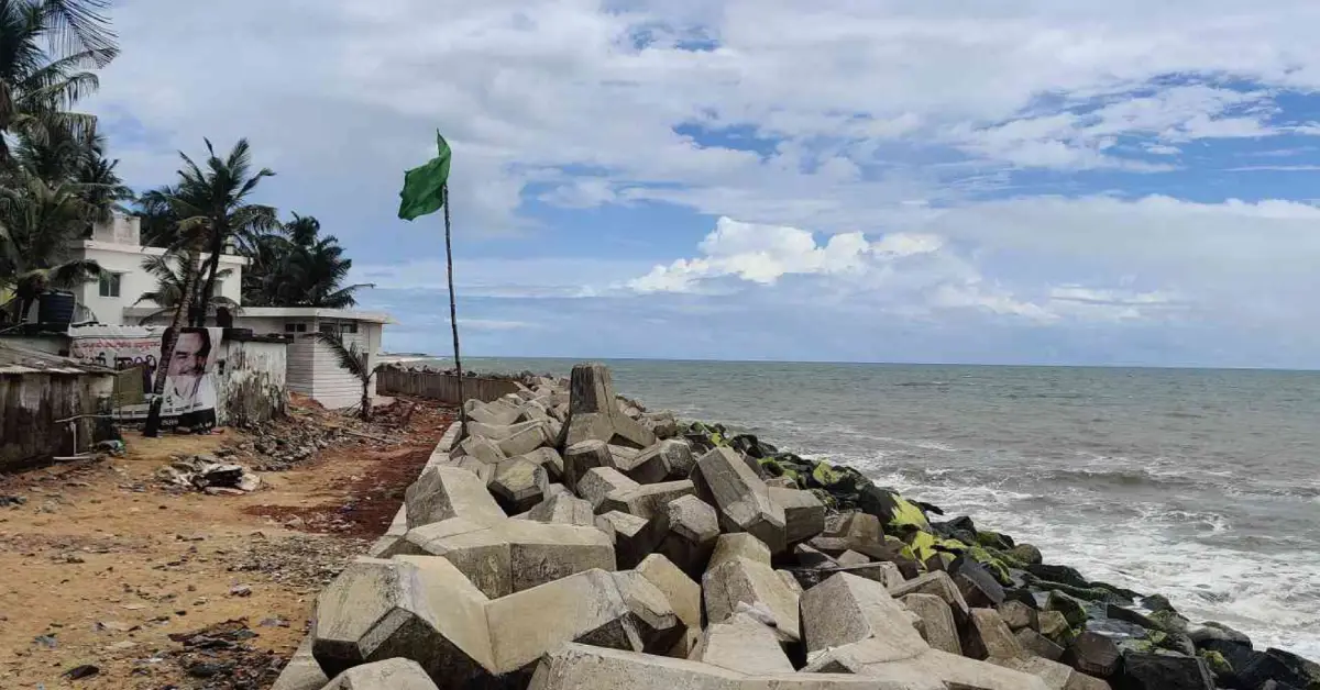
A proposed 22-km coastal road between Ullal and Surathkal is being pitched as a permanent seawall and a high-speed corridor in one. For a coastline that has buried houses in the sea nearly every monsoon for two decades, the idea is tempting — but the community's own history with erosion projects offers reasons for caution.
A Monsoon Ritual Nobody Wants
For families along the stretch from Ullal to Uchila, the monsoon has arrived every year for two decades with the same question: will the sea take the house this time.
It has, repeatedly. Boulders dumped as emergency defences have been picked up by rough seas and flung "like footballs" at homes, in the words of one local legislator watching the damage. Houses have been rebuilt three times over by residents with no insurance, because insurers routinely decline to cover homes sited this close to an eroding shoreline. In a single bad week, as many as 50 houses and two mosques across Ullal and Uchila have faced the threat of being washed away.
Against that backdrop, a new proposal has generated real hope along the coast: a 22-km road connecting Ullal to Surathkal, engineered to double as a permanent seawall.
What's Actually Being Proposed
In March 2026, the Dakshina Kannada district administration mooted the project — a coastal corridor designed for two purposes at once. It would function as a high-speed transit route connecting the southern and northern ends of Mangaluru's coastline, and its foundation would be engineered as permanent anti-erosion infrastructure, replacing the temporary stone barriers and boulder-dumping that residents have watched fail, year after year, for a generation.
The pitch is straightforward: instead of building a road here and a seawall there, at recurring cost each monsoon, build one structure that does both jobs permanently. Officials have said the design is meant to strictly follow Coastal Regulation Zone (CRZ) guidelines even as it reshapes the shoreline it runs along.
The project has already begun shaping expectations well beyond erosion control. Property analysts anticipate rising land values along the corridor, with investor interest building in Mukka, Hosabettu and Ullal — areas being reimagined as future sites for sea-view flats and gated communities, on the promise of a secure, well-connected coast.
What the 22-km Coastal Road Proposes
| # | Element | Detail |
|---|---|---|
| 1 | Route | Ullal to Surathkal, approximately 22 km |
| 2 | Proposing authority | Dakshina Kannada district administration |
| 3 | Announced | March 2026 |
| 4 | Stated dual purpose | High-speed transit corridor + permanent seawall |
| 5 | Regulatory framing | Designed to adhere to CRZ guidelines |
| 6 | Anticipated side effect | Rising land values and investor interest in Mukka, Hosabettu, Ullal |
| 7 | Status as of writing | Awaiting final government clearances |
The Coast's Long, Difficult History With "Permanent" Solutions
To weigh what this proposal might deliver, it helps to know what came before it.
Ullal's most significant recent success is a reinforced seawall completed in 2019, built with technical and financial support from the Asian Development Bank, standing roughly eight feet tall along a stretch of the settlement. Residents describe it, cautiously, as good work — a genuine improvement after a decade in which the government's coastal defences were largely a graveyard of failed attempts: rocks, then more rocks, then oversized sandbags, each dismantled in turn by a violent monsoon sea.
But even the projects that followed the 2019 wall have run into friction. A subsequent Asian Development Bank-backed erosion project for Ullal, implemented through the Sustainable Coastal Protection and Management Investment Programme, drew criticism from the fishermen's community before construction had even properly begun. Fishermen alleged they had been kept in the dark about the project's plans for years, and objected specifically to the construction sequence — arguing that inshore berms were being built before the offshore reefs and realigned breakwaters that were supposed to reduce wave strength first, a sequencing error that, in their view, risked the berms simply washing away as they had before.
The government's response to that friction is itself instructive: it later set up community-based Shoreline Management Organisations in Ullal, Bengre and Surathkal specifically to give residents a formal channel into project decisions, with reserved representation for women, precisely because the earlier consultation gap had caused real damage to trust.
That history matters here because the 22-km road-seawall is, structurally, an even larger and more consequential intervention than anything attempted before on this coast.
The coastal road is not the only erosion initiative in motion along this stretch, and it is worth being precise about how the pieces relate — because the public record does not yet spell this out clearly.
Separately from the road proposal, the Karnataka Water Transport Board has been implementing a Shoreline Management Plan since at least August 2026, covering a 37.34-km stretch of Dakshina Kannada's coastline under the banner "Our Coast, Our Lifeline." Built on a scientific assessment by the National Centre for Sustainable Coastal Management in Chennai, and following National Green Tribunal directions under the CRZ 2019 framework, this plan has already held a public consultation in Ullal, with further consultations planned in Surathkal and Mulki before a detailed project report is finalised.
Then, at the Karnataka Cabinet's landmark Mangaluru meeting on 18 September 2026, ministers approved a revision of the district's Coastal Zone Management Plan 2019 — a revision explicitly triggered by representations from fishermen, tourism stakeholders, landowners and local bodies over mismatches between approved CRZ maps and ground realities.
Coastal Protection Efforts Currently in Motion in Dakshina Kannada
| Initiative | Scope | Status |
|---|---|---|
| 22-km Ullal-Surathkal coastal road/seawall | Ullal to Surathkal | Proposed March 2026; awaiting government clearances |
| Shoreline Management Plan (Karnataka Water Transport Board) | 37.34 km of Dakshina Kannada coastline | NCSCM report submitted; public consultations ongoing (Ullal held, Surathkal and Mulki planned) |
| Coastal Zone Management Plan 2019 revision | District-wide CRZ mapping | Approved in principle by Cabinet, 18 September 2026 |
| 2019 Ullal seawall (ADB-supported) | Section of Ullal shoreline | Completed |
Whether the 22-km road is being folded into the Shoreline Management Plan, run as a fully separate scheme, or eventually reconciled with the revised CZMP is not something available reporting makes explicit. Readers should treat these as three related but distinct processes until an official document says otherwise.
The Case For: An End to Annual Devastation
The argument for the road-seawall is not abstract to anyone who has lived through even one bad monsoon on this coast. A permanently engineered structure, built to modern standards rather than reactive boulder-dumping, could plausibly end the yearly cycle of damage, displacement and uninsurable rebuilding that has defined life in Kaiko, Mogaveerapattana, Kotepura and similar settlements for two decades.
Combining that protection with a transit corridor also solves a second, less discussed problem: connectivity along a coastline that has historically been served by roads set back from the water, making the shortest, most scenic route between Mangaluru's southern and northern suburbs harder to build than it should be. A single structure serving both purposes could be more efficient, in both cost and land use, than building each separately — the same logic the district administration used to justify the design.
The Case for Caution: What "Reshaping" Could Mean
The counterweight is what a 22-km hard structure running the length of the coast could do to the communities living beside it — and the coast's own project history offers specific warnings, not hypothetical ones.
First, consultation. The fishermen's objections to the earlier Ullal erosion project were not about opposing protection in principle — they were about not being consulted on design and sequencing until construction was already underway. A project roughly running the entire Ullal-Surathkal coastline is a far larger canvas for that same failure to repeat, at far greater cost if it does.
Second, land value pressure. Property analysts are already framing this project as a trigger for a real estate surge in Mukka, Hosabettu and Ullal. For existing fishing families whose homes and boat access sit precisely where "sea-view residences" and "gated community plots" are now being anticipated, rising land values are not obviously good news — they can just as easily precede pressure to sell, relocate, or lose informal access to the shore their livelihoods depend on.
Third, CRZ complexity. The same Cabinet session that touched coastal Mangaluru approved a CZMP revision specifically because existing coastal maps did not match ground realities, following complaints from fishermen and landowners alike. A 22-km linear structure through this same zone will need to navigate exactly the kind of mapping disputes that revision was meant to resolve — and the sequencing of that regulatory reconciliation, relative to the road's own clearances, is not yet public.
Fourth, ecological change. A seawall changes how sand moves along a coast, not just whether it erodes in place — the earlier Ullal project's entire technical dispute was about exactly this, whether breakwaters needed to be realigned before or after other structures to keep the coast's natural sand equilibrium intact. A structure four times the length of anything built on this coast before raises the same question at a much larger scale, with no public technical study yet available on what it means for beaches, fish breeding grounds, or neighbouring unprotected stretches.
What to Watch For Next
Three things will tell you more about which way this project is heading than any press release. First, whether a detailed project report is published for the 22-km stretch specifically, rather than folded silently into the Shoreline Management Plan's 37.34-km scope. Second, whether Shoreline Management Organisations, or an equivalent community body, are formally consulted on this project the way they were set up to be after the last round of friction. Third, whether the revised Coastal Zone Management Plan, once finalised, treats the road-seawall corridor as a special case or leaves its regulatory status ambiguous.
For a coast that has spent twenty years choosing between temporary protection and no protection at all, a genuinely permanent solution would be transformative. Whether this one delivers that, or instead trades one kind of coastal precarity for another, depends entirely on decisions that have not yet been made public.
Read Next on Mangalore Diary
- Mangaluru's Beaches Are Changing: What Happened to the Coast We Grew Up With?
- The People Who Start Mangaluru's Fish Market Before the City Wakes Up
- "From Boat to University": The Making of Mangaluru's Fisheries and Blue Economy Hub
- Mangalore Port Records Highest Cargo Throughput FY2025
FAQ
What is the 22-km coastal road project between Ullal and Surathkal?
A proposal, mooted by the Dakshina Kannada district administration in March 2026, to build a 22-km road along the Mangaluru coastline that is engineered to also function as a permanent seawall against coastal erosion.
Has the project been approved?
As of this writing, the project awaits final government clearances. It has been proposed and is undergoing planning, but has not been confirmed as fully sanctioned or under construction.
Is this the same as the Shoreline Management Plan or the Coastal Zone Management Plan revision?
Not clearly. The Shoreline Management Plan is a separate, ongoing 37.34-km coastal protection initiative led by the Karnataka Water Transport Board. The Coastal Zone Management Plan 2019 revision, approved in principle by the Cabinet on 18 September 2026, addresses CRZ mapping issues district-wide. How the 22-km road relates to either process is not made explicit in available public reporting.
Why has coastal erosion been such a persistent problem in Ullal
The area has faced annual monsoon erosion for roughly two decades, with temporary measures like stone bunds and sandbags repeatedly destroyed by rough seas. A more durable seawall was completed in 2019 with Asian Development Bank support, offering some relief, but erosion continues to threaten homes in several stretches.
What concerns have fishing communities raised about past coastal protection projects here?
In an earlier Ullal erosion-control project, fishermen alleged they were not consulted on the project's plans for years and objected to the construction sequence, arguing offshore reefs and breakwaters needed to be built before inshore berms to be effective.
Could the coastal road project affect property prices and existing communities?
Property analysts anticipate rising land values and increased investor interest in Mukka, Hosabettu and Ullal following the proposal, which could bring both economic opportunity and pressure on existing fishing families and long-term residents along the corridor.




0 Comments
Leave a Comment